


OVERVIEW of ONSPD
The ONS Postcode Directory (ONSPD) relates both current and terminated postcodes in the UK to a range of current statutory administrative, electoral, health and other area geographies.
It also links postcodes to pre-2002 health areas, 1991 Census Enumeration Districts (for England and Wales), and both 2001 and 2011 Census Output Areas (OA) and Super Output Areas (SOA). The directory is issued quarterly.
From our experience, the data has so much potential that each client usage is dependent on what they want to achieve.
Some will only be interested in one particular value, say the Clinical Commissioning Group, or the Parliamentary Constituency, and will depend on their area of business, others will use grid references which cross a wider industry usage.
TO ACCESS ONSPD REGISTER FOR AN ADDRESS LOOKUP SERVICE ACCOUNT
INTEGRATION, STANDALONE OR BUREAU SERVICE
NOT SURE WHICH IS BEST APPROACH?
BENEFITS of ONSPD
Improve Delivery and Services
Plotting on a map grid references contained in ONSPD in conjunction with postcodes in PAF, will help in planning deliveries and services.

Improve Analysis
Use NHS codes for geographical analysis at a small level without compromising patient confidentiality since NHS codes are not exclusive to just the NHS.

Understand Key Demographics
Aspects of the ONSPD, such as Index of Multiple Deprivation and Urban Rural Indicator 2001, gives you an understanding of demographics, both compared to other local authorities and in a single local authority.
INFORMATION ABOUT THE ONSPD DATASET
The postcode is key data that provides a geo-spatial reference for many uses beyond the delivery of mail.
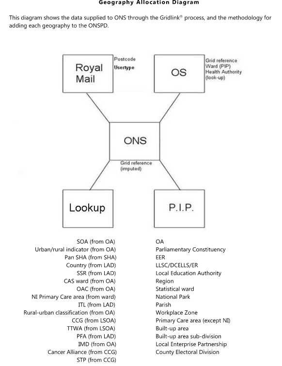
To make full use of its potential, and to deliver improved consistency, a consortium of organisations were formed in 1999 to allow the specialist resources of each member to be pooled.
The Gridlink Consortium consists of Royal Mail Group plc, OS (GB), National Records of Scotland (NRS), Northern Ireland Land and Property Services (LPS) and ONS.
The Gridlink methodology is used to create the ONSPD, based on 1-metre grid references and digital administrative and electoral area boundaries.
This creates a core set of data:
- All current (live) UK unit postcodes (but ONS maintains postcodes terminated and not subsequently re-used by Royal Mail)
- Grid references to 1 metre resolution
- Positional quality indicators for grid references
- UK country codes
- Electoral ward codes
- Administrative local authority district code.
- Administrative unitary authority codes
- Administrative county codes
- Health regional area codes
- Health authority codes
WHY USE HOPEWISER?
The ONSPD dataset is available online, integrated into your software, or via a bureau service.
We can provide bespoke systems tailored to your specific requirements and CRM integrations.
By using the data via our Online Portal you will access address lookup software including REST API and software that is AutoComplete compatible.
PAF data is updated daily and the ONSPD will be updated quarterly.
ONSPD does not contain Member of Parliament names, but Hopewiser maintain and add these, updating after any election.
Hopewiser has always been data agnostic. We can work with the dataset to understand and build a comprehensive solution providing the enrichment or analysis you need.
We are happy to discuss your requirements and help identify the right solution for you, get in touch here.
OTHER DATASETS AVAILABLE
The following datasets are a selection of what is also available. Please contact us for the full list.
International
International datasets for many countries, including Ireland, USA, Australia and New Zealand.

Ordnance Survey
Ordnance Survey data available including AddressBase Premium.
PAF
Access to 1.8 million UK postcodes and 30 million residential and business addresses including Not Yet Built and Multiple Residence.
Companies House
Company information from Companies House, including registered office address, filing history, accounts and annual return.